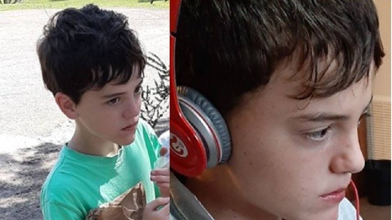
Placeholder Content Image

Why hurricanes like Milton in the US and cyclones in Australia are becoming more intense and harder to predict

<div class="theconversation-article-body"><em><a href="https://theconversation.com/profiles/andrew-dowdy-119002">Andrew Dowdy</a>, <a href="https://theconversation.com/institutions/the-university-of-melbourne-722">The University of Melbourne</a>; <a href="https://theconversation.com/profiles/liz-ritchie-tyo-1509061">Liz Ritchie-Tyo</a>, <a href="https://theconversation.com/institutions/monash-university-1065">Monash University</a>, and <a href="https://theconversation.com/profiles/savin-chand-1351050">Savin Chand</a>, <a href="https://theconversation.com/institutions/federation-university-australia-780">Federation University Australia</a></em></p> <p>Tropical cyclones, known as hurricanes and typhoons in other parts of the world, have caused huge damage in many places recently. The United States has just been hit by <a href="https://www.nhc.noaa.gov/graphics_at4.shtml?start">Hurricane Milton</a>, within two weeks of <a href="https://theconversation.com/how-hurricane-helene-became-a-deadly-disaster-across-six-states-240522">Hurricane Helene</a>. Climate change <a href="https://www.worldweatherattribution.org/climate-change-key-driver-of-catastrophic-impacts-of-hurricane-helene-that-devastated-both-coastal-and-inland-communities/">likely made their impacts worse</a>.</p> <p>In Australia, the tropical cyclone season (November to April) is approaching. The Bureau of Meteorology this week released its <a href="http://www.bom.gov.au/climate/cyclones/australia/">long-range forecast</a> for this season.</p> <p>It predicts an average number of tropical cyclones, 11, are likely to form in the region. Four are expected to cross the Australian coast. However, the risk of severe cyclones is higher than average.</p> <p>So what does an average number actually mean in our rapidly changing climate? And why is there a higher risk of intense cyclones?</p> <p>The bureau’s forecast is consistent with scientific evidence suggesting climate change is likely to result in fewer but more severe tropical cyclones. They are now more likely to bring stronger winds and <a href="https://hess.copernicus.org/articles/28/1251/2024/hess-28-1251-2024.pdf">more intense rain and flooding</a>.</p> <h2>Climate change is making prediction harder</h2> <p>Our knowledge of tropical cyclones and climate change is based on multiple lines of evidence <a href="https://doi.org/10.1175/BAMS-D-18-0189.1">globally</a> and for the Australian region. This work includes our studies based on <a href="https://www.nature.com/articles/s41558-022-01388-4">observations</a> and <a href="https://link.springer.com/article/10.1007/s00382-018-4497-4">modelling</a>.</p> <p>The bureau’s seasonal outlook in recent years has assumed an average of 11 tropical cyclones occurring in our region (covering an area of the southern tropics between longitudes 90°E and 160°E). It’s based on the average value for all years back to 1969.</p> <p>However, for the past couple of decades the annual average is below nine tropical cyclones. In earlier decades, it was over 12. This long-term downward trend adds to the challenge of seasonal predictions.</p> <p>The most recent above-average season (assuming an average of 11) was almost 20 years ago, in the <a href="http://www.bom.gov.au/cyclone/tropical-cyclone-knowledge-centre/history/climatology/">2005–06 summer with 12 tropical cyclones</a>. Since then, any prediction of above-average tropical cyclone seasons has not eventuated.</p> <h2>El Niño and La Niña influences may be changing too</h2> <p>Historical observations suggest more tropical cyclones tend to occur near Australia during La Niña events. This is a result of warm, moist water and air near Australia, compared with El Niño events. The shifting between El Niño and La Niña states in the Pacific region is known as the El Niño-Southern Oscillation (ENSO).</p> <p>Such events can be predicted with a useful degree of accuracy several months ahead in some cases. For example, the US National Oceanic and Atmospheric Administration (NOAA) has <a href="https://www.cpc.ncep.noaa.gov/products/analysis_monitoring/lanina/enso_evolution-status-fcsts-web.pdf">forecast</a>:</p> <blockquote> <p>La Niña is favored to emerge in September–November (71% chance) and is expected to persist through January–March 2025.</p> </blockquote> <p>Based on that, one might expect a higher-than-average number of tropical cyclones for the Australian region. However, the <a href="https://rmets.onlinelibrary.wiley.com/doi/abs/10.1002/asl2.502">ENSO influence on tropical cyclones has weakened</a> in our region. It’s another factor that’s making long-range predictions harder.</p> <p>The <a href="http://www.bom.gov.au/climate/enso/outlook/">bureau’s ENSO outlook</a> is somewhat closer to neutral ENSO conditions, based on its modelling, compared to NOAA’s leaning more toward La Niña. The bureau says:</p> <blockquote> <p>Should La Niña form in the coming months, it is forecast to be relatively weak and short-lived.</p> </blockquote> <p>The bureau’s prediction of an average number of tropical cyclones this season is broadly consistent with its prediction of close-to-average ENSO conditions.</p> <h2>So what does this all mean for this cyclone season?</h2> <p>If we end up getting an average Australian season for the current climate, this might actually mean fewer tropical cyclones than the historical average. The number might be closer to eight or nine rather than 11 or 12. (Higher or lower values than this range are still possible.)</p> <p>However, those that do occur could have an increased chance of being <a href="http://www.bom.gov.au/cyclone/tropical-cyclone-knowledge-centre/understanding/categories/">category 4 or 5 tropical cyclones</a>. These have stronger winds, with gusts typically exceeding 225km per hour, and are more likely to cause severe floods and coastal damage.</p> <p>If we end up getting more than the recent average of eight to nine tropical cyclones, which could happen if NOAA predictions of La Niña conditions eventuate, that increases the risk of impacts. However, there is one partially good news story from climate change relating to this, if the influence of La Niña is less than it used to be on increasing tropical cyclone activity.</p> <p>Another factor is that the <a href="http://www.bom.gov.au/climate/ocean/sst/#/anom/global/weekly/20241006">world’s oceans are much warmer than usual</a>. Warm ocean water is one of several factors that provide the energy needed for a tropical cyclone to form.</p> <p>Many ocean heat <a href="https://climatereanalyzer.org/clim/sst_daily/?dm_id=world2">records have been set</a> recently. This means we have been in “uncharted waters” from a temperature perspective. It adds further uncertainty if relying on what occurred in the past when making predictions for the current climate.</p> <h2>Up-to-date evidence is vital as climate changes</h2> <p>The science makes it clear we need to plan for tropical cyclone impacts in a different way from what might have worked in the past. This includes being prepared for potentially fewer tropical cyclones overall, but with those that do occur being more likely to cause more damage. This means there are higher risks of damaging winds, flooding and coastal erosion.</p> <p>Seasonal prediction guidance can be part of improved planning. There’s also a need for enhanced design standards and other climate change adaptation activities. All can be updated regularly to stay consistent with the best available scientific knowledge.</p> <p>Increased preparedness is more important than ever to help reduce the potential for disasters caused by tropical cyclones in the current and future climate.</p> <hr /> <p><em>The authors acknowledge the contribution of CSIRO researcher <a href="https://theconversation.com/profiles/hamish-ramsay-19549">Hamish Ramsay</a> during the writing of this article.</em><!-- Below is The Conversation's page counter tag. Please DO NOT REMOVE. --><img style="border: none !important; box-shadow: none !important; margin: 0 !important; max-height: 1px !important; max-width: 1px !important; min-height: 1px !important; min-width: 1px !important; opacity: 0 !important; outline: none !important; padding: 0 !important;" src="https://counter.theconversation.com/content/241000/count.gif?distributor=republish-lightbox-basic" alt="The Conversation" width="1" height="1" /><!-- End of code. If you don't see any code above, please get new code from the Advanced tab after you click the republish button. The page counter does not collect any personal data. More info: https://theconversation.com/republishing-guidelines --></p> <p><a href="https://theconversation.com/profiles/andrew-dowdy-119002"><em>Andrew Dowdy</em></a><em>, Principal Research Scientist in Extreme Weather, <a href="https://theconversation.com/institutions/the-university-of-melbourne-722">The University of Melbourne</a>; <a href="https://theconversation.com/profiles/liz-ritchie-tyo-1509061">Liz Ritchie-Tyo</a>, Professor of Atmospheric Sciences, <a href="https://theconversation.com/institutions/monash-university-1065">Monash University</a>, and <a href="https://theconversation.com/profiles/savin-chand-1351050">Savin Chand</a>, Associate Professor, Applied Mathematics and Statistics, <a href="https://theconversation.com/institutions/federation-university-australia-780">Federation University Australia</a></em></p> <p><em>Image credits: Shutterstock </em></p> <p><em>This article is republished from <a href="https://theconversation.com">The Conversation</a> under a Creative Commons license. Read the <a href="https://theconversation.com/why-hurricanes-like-milton-in-the-us-and-cyclones-in-australia-are-becoming-more-intense-and-harder-to-predict-241000">original article</a>.</em></p> </div>

Travel Trouble

Placeholder Content Image

Man clinging to esky rescued after Hurricane Milton ravages entire state

<p>A man has been dramatically rescued after he drifted more than 50km out to sea after being hit by the terrifying storm of Hurricane Milton. </p> <p>The record-breaking storm system ravaged the US state of Florida on Thursday, as the death toll has risen to 14 at the time of writing.</p> <p>One fisherman survived the storm by clinging to an esky and was rescued by the US Coast Guard in the Gulf of Mexico after his boat was stranded overnight in dangerous waters.</p> <p>“This man survived in a nightmare scenario for even the most experienced mariner,” Lieutenant Commander Dana Grady of the US Coast Guard said of the dramatic rescue.</p> <p>“To understand the severity of the hurricane conditions, we estimate he experienced approximately 75 to 90mph winds, 20- to 25-foot (six to seven metre ) seas, for an extended period of time to include overnight."</p> <p>“He survived because of a lifejacket, his emergency position indicating locator beacon and a cooler.”</p> <p>The storm swept through the city of Tampa, causing widespread destruction throughout the south-east of the state, with many residents now dealing with power outages and extensive debris. </p> <p>Amongst those stranded during the flash flooding were 135 residents of an aged care home, with many  wheelchair-bound residents spending the night sitting in water up to their waste before they were rescued the next morning.</p> <p>“This is a neighbourhood that doesn’t have a lot … They’ve lost everything,” Hillsborough County Sheriff Chad Chronister told <em>CNN</em>.</p> <p>“These are people who live day-to-day and they have nothing … Your heart shatters for these people.”</p> <p>Florida Governor Ron DeSantis said, “We’ll survey the damage and get people back on their feet – we’ll get through this.”</p> <p><em>Image credits: Instagram - US Coast Guard</em></p>

Travel Trouble

Our Partners